“这项针对旧金山湾区提出的计划意识到将沉积物从河流引入潮汐生态系统中的湿地和滩涂的重要性,并将其作为维护健康社区和应对气候变化导致的海平面上升的手段。在社区的积极投入下,这一具有革新性的计划提出重新设计阿拉米达溪的河道以更好地运输沉积物、为鱼类提供栖息地并在沿岸创造更丰富的公共空间。该方案将以上问题列入了景观设计师的日常议程,使沉积物从废料转变为我们在试图控制不断变化的河岸的过程中所能把握的最有价值的事物。”
– 2019年评审委员会
“This proposal for the San Francisco Bay Area recognizes the importance of allowing sediment to flow from streams into the marshes and mudflats of tidal ecosystems as a means of maintaining healthy communities and to combat rising sea levels caused by climate change. Created with significant community input, this paradigm-shifting plan recommends the redesign of the Alameda Creek to better transport sediment, provide fish habitats, and create opportunities for public spaces along the waterway. It helps puts the issue on the agenda for landscape architects and treats sediment not as waste but as one of the most valuable things we can hold on to as coastal processes are changing.” – 2019 Awards Jury
湾区的潮汐生态系统(湿地和滩涂)正面临着沉陷和被淹没的危险,同时伴随着沉积物补给的匮乏和海平面的上升。阿拉米达溪公共沉积物规划方案指出,必须通过拓宽上游来适应海平面上升的状况,并通过重新设计沉积物径流来维持潮汐生态系统,使脆弱的社区得到保护。该计划的目的是重新连接河流与湾区;为湾区的土地提供可持续的沉积物供给以应对海平面的上升;使鱼类回归长期以来的产卵地;引入新的社区空间网络,使溪流重新回到人们的生活当中。该方案展现了针对气候变化所进行的规划的范式转变:在应对海平面上升的问题时,我们要做的并非巩固邻水地带的边界,而是要重新调整沉积物与水资源之间的关系,同时尽力去维护随时间不断壮大的生物系统。该项目在社区的利益相关者们对“用设计构建适应力”(Resilient by Design)这一倡议的广泛投入下得以创建,随后获得了来自国家海岸恢复基金会的试点资金支持。
The Bay Area’s tidal ecosystems—its marshes and mudflats—are at risk of subsidence and drowning with low sediment supply and sea level rise. Public Sediment for Alameda Creek proposes that sea level rise adaptation must extend upstream, redesigning sediment flows to sustain tidal ecosystems and protect vulnerable communities. Public Sediment for Alameda Creek is a plan to reconnect the creek with the bay, provide a sustainable supply of sediment to baylands for sea level rise adaptation, reconnect migratory fish with their historic spawning grounds, and introduce a network of community spaces that reclaim the creek as a place for people. The proposal represents a paradigm shift in how we plan for climate change. Rather than hardening the edge, we must recalibrate our relationship with sediment and water resources and invest today in living systems that will grow over time to adapt to sea level rise. The project was created with extensive input from community stakeholders for the Resilient by Design initiative and has since continued with pilot funding from the National Coastal Resilience Fund.

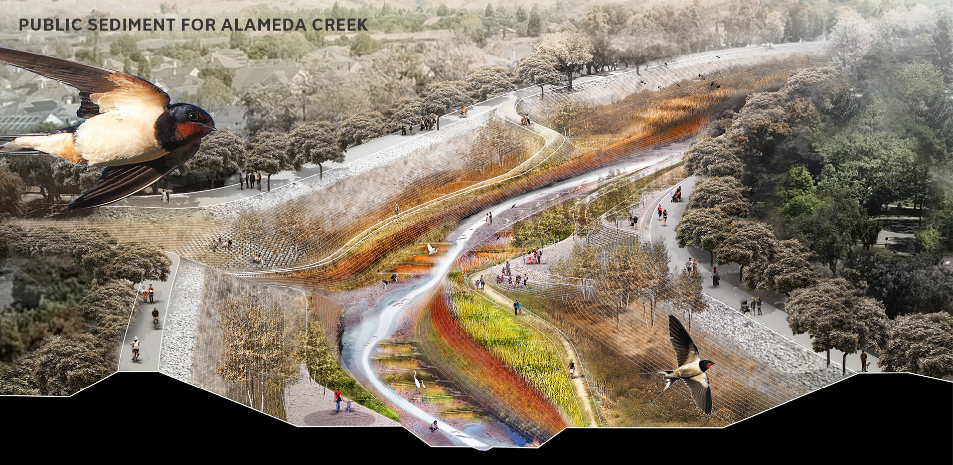
▲从沟渠到河流:尽管无法恢复河流系统过去的状态,该项目提议重新引入可持续的沉积物径流、建立生态连通性以及重新进入河岸的公共路径,以应对未来气候变化的威胁。From Channel to Creek: While the system can never return to its past state, the project proposes to reintroduce sustainable sediment flows, ecological connectivity, and public access back to the creek to address future climate change threats.
潮汐生态系统是一种保护性的基础设施,能够为旧金山湾区城市的边缘提供缓作用。这些系统需要沉积物在垂直方向上增长以适应海平面的上升——如果没有沉积物,我们的海湾将会被淹没。由上游水坝和渠道化工程导致的沉积物匮乏将引发缓慢却具有毁灭性的大规模损失,不仅对生态系统和休闲景观是一种巨大威胁,还会让成千上万的居民面临用水安全、能源和运输系统方面的风险。
阿拉米达溪公共沉积物计划旨在应对和解决菲蒙市、联合市以及纽瓦克市的脆弱沿海地带的沉积物短缺问题。为了将沉积物带入湾区陆地并适应海平面的上升,我们的团队将目光聚焦在当地最大的支流阿拉米达溪的上游地带,旨在通过重新设计水体来创造以可持续方式运输沉积物的功能性系统,以此来适应海平面的上升、吸引居民的参与并为溯河产卵的鱼类提供栖息环境。
阿拉米达溪曾实施渠道化工程以保护菲蒙市、联合市以及纽瓦克市的社区免受极端洪水的侵害。过去的阿拉米达溪通过沉积物直接为湾区陆地提供滋养,并长期维护着栖息地的基础构造。而如今,渠道的修建使得湾区的生命系统日渐僵化,使其无法恢复到原先的状态。在这一背景下,阿拉米达溪公共沉积物计划提议重新引入可持续的沉积物径流、建立生态连通性以及重塑通往溪流的公共路径,以应对未来气候变化的威胁。该项目在阿拉米达郡防洪区实施的既有工程(低流量渠道)的基础上得以开展,其实施过程得益于阿拉米达溪流域的多方合作伙伴的共同努力,包括阿拉米达溪联盟、阿拉米达郡水区以及渔业恢复工作小组等。
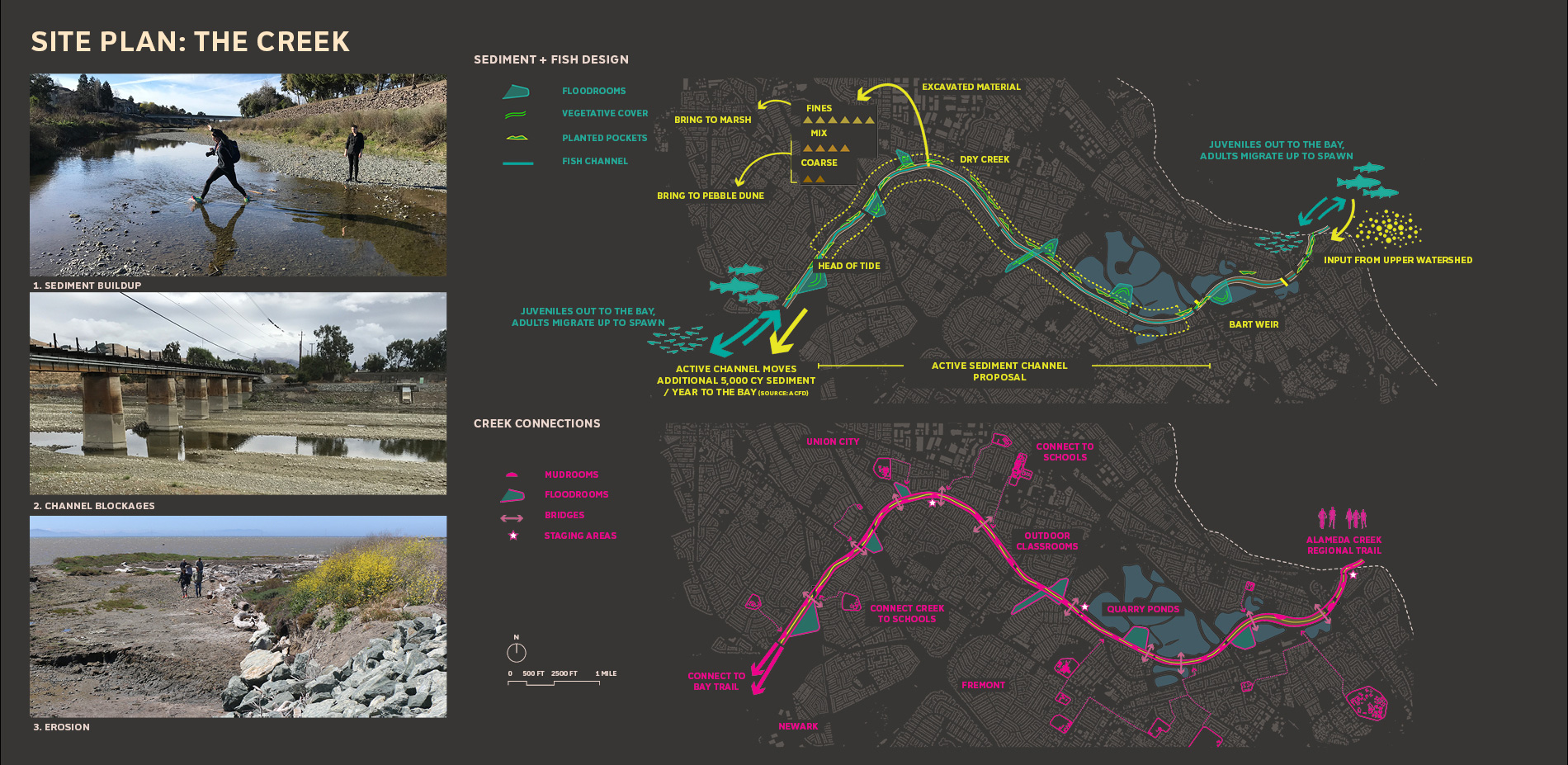
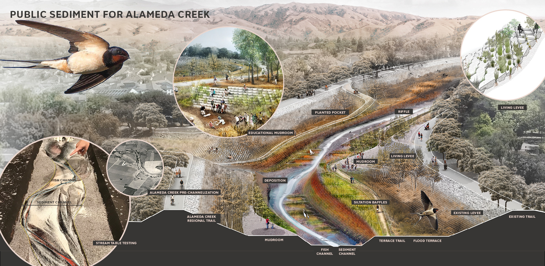
渠道本身并不能起到输送沉积物的作用。如今,粗颗粒的沉积物在河道中聚积,降低了存蓄洪水的能力,并且需要不断地进行疏浚工作。该项目提出对渠道进行重新设计,挖掘出一条与水岸持平的新渠道,从而在每年洪水量最大时将沉积物输送至下游,并借助植被来稳固地形。新的渠道预计每年可以向湾区多输送5000立方码的沉积物,在创造栖息地的同时带来了横跨河流的公共通道。
连续的河道是许多生物赖以生存的家园。在历史上,阿拉米达溪曾经栖息着当地体积最庞大的硬头鳟,如今却由于渠道化工程和道路障碍而逐渐消失。整体规划中已经在基础设施的交叉口设置了鱼梯,但即便做出了这样的改进,阿拉米达溪宽而浅的截面仍然对硬头鳟的迁徙形成了阻碍。本次计划提议建造一条更深的鱼道,使鱼类可以借助更深的水流成功迁移,同时还将为渠道引入更多样的植被。蓄洪室的修建扩展了必不可少的觅食区和避难区,为河滩上包括硬头鳟在内的各类生物提供了理想的栖息环境。
既有的渠道化工程和护堤设施还为菲蒙市、联合市以及纽瓦克市周边带来了影响,使得富裕阶层、中等收入阶层和贫困阶层的社区分化得更加明显。尽管堤坝上的步道很受环境,但人群依然被隔离在顶部的边缘地带,无法近距离地接触和跨越河岸,也无法与变化的河流系统形成真正的互动。本次计划提出建设四种类型的公共通道,包括泥沙室、蓄洪室、平台步道以及四季桥梁,它们分别回应了不同的洪流活动,并在冬季对通行路径进行相应调整。
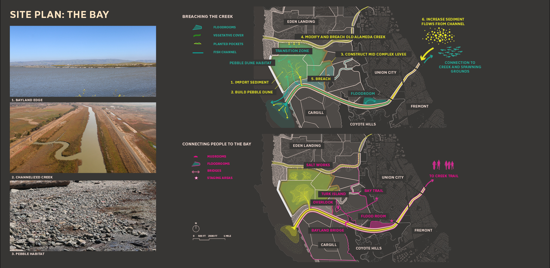
该计划拟在沉积物径流与位于Eden Landing的潮汐湾地之间建立直接的连接。对于湾区陆地的长期发展而言,水流的引导起着至关重要的作用:即使在脆弱状态下,阿拉米达溪的水道也能够输送足够的沉积物以滋养恢复后的潮汐湿地,从而适应海平面的上升。引流工作看似简单,实际上受到复杂的物理条件和规章制度的约束,需要平衡洪水风险、各方责任、生境状态和公共路径等多方面的要求。本次计划方案旨在通过连接河流和湾区陆地来协调湾区边缘的人、沉积物以及鱼类的生存环境,并以南湾盐池的修复项目(South Bay Salt Pond Restoration Project)为基础,将具体计划分为Eden Landing、加州鱼类和野生动物区、阿拉米达郡防洪区以及东湾区域公园、湾区步道等多个部分。
计划提出了一个分多步完成的策略,最终目的是将沉积物与湾区陆地连接起来,并解决长期和短期的洪水风险。洪水风险放空的一系列措施包括修筑一道用于分隔人工池塘和潮汐池塘的堤坝,和一座模仿防洪岛屿的“卵石沙丘”,以减缓潮汐力并防止海湾陆地受到浪潮侵袭。这些干预措施实现了阿拉米达溪的分流并使沉积物能够进入湾区陆地,并随着时间的推移不断滋养新的湿地垫层。
溪流的渠道化工程严重限制了河口混合带的生态发展,将原来宽阔而蜿蜒的湿地平原变成了单一的线性渠道。新造的河口重新引入了混合带,为多种生物创造了过渡性的栖息空间,使其可以在未来适应盐水环境。
方案还包括在湾区陆地建造一系列新景点,包括海湾步道以及一座俯瞰河口的桥梁,从而将湾区连接至Eden Landing广阔的步道网络,同时带来面向新三角洲的清晰视野。
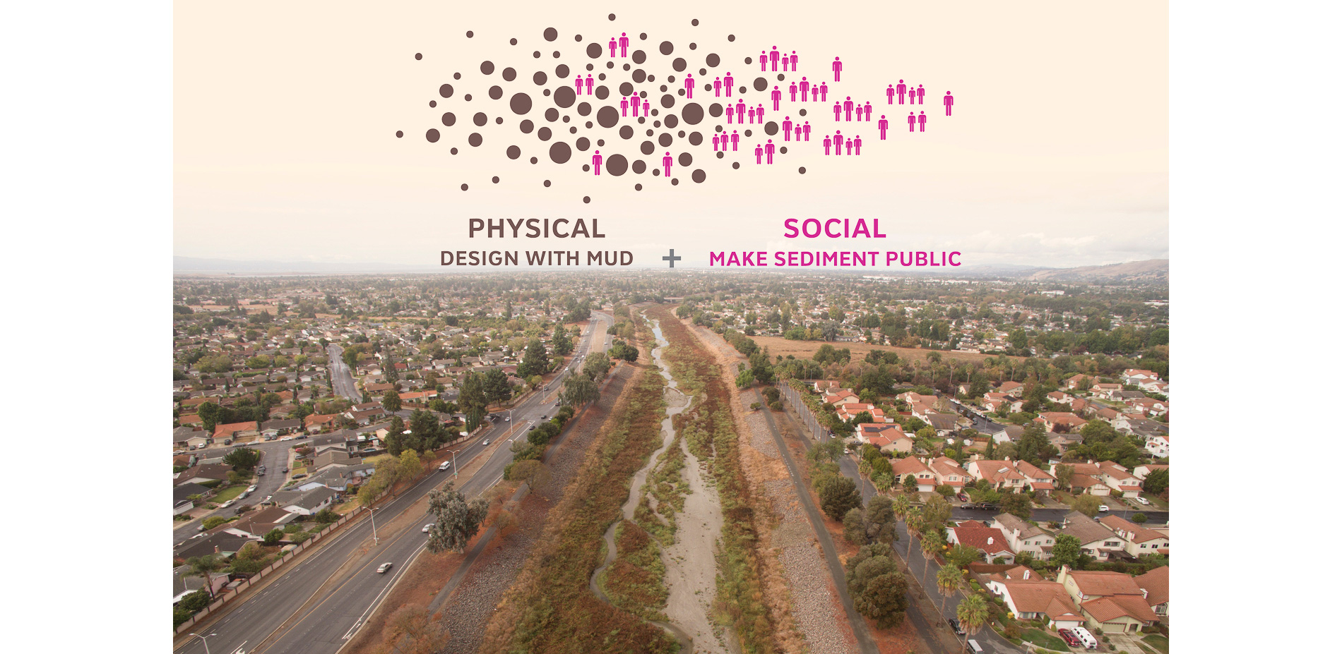
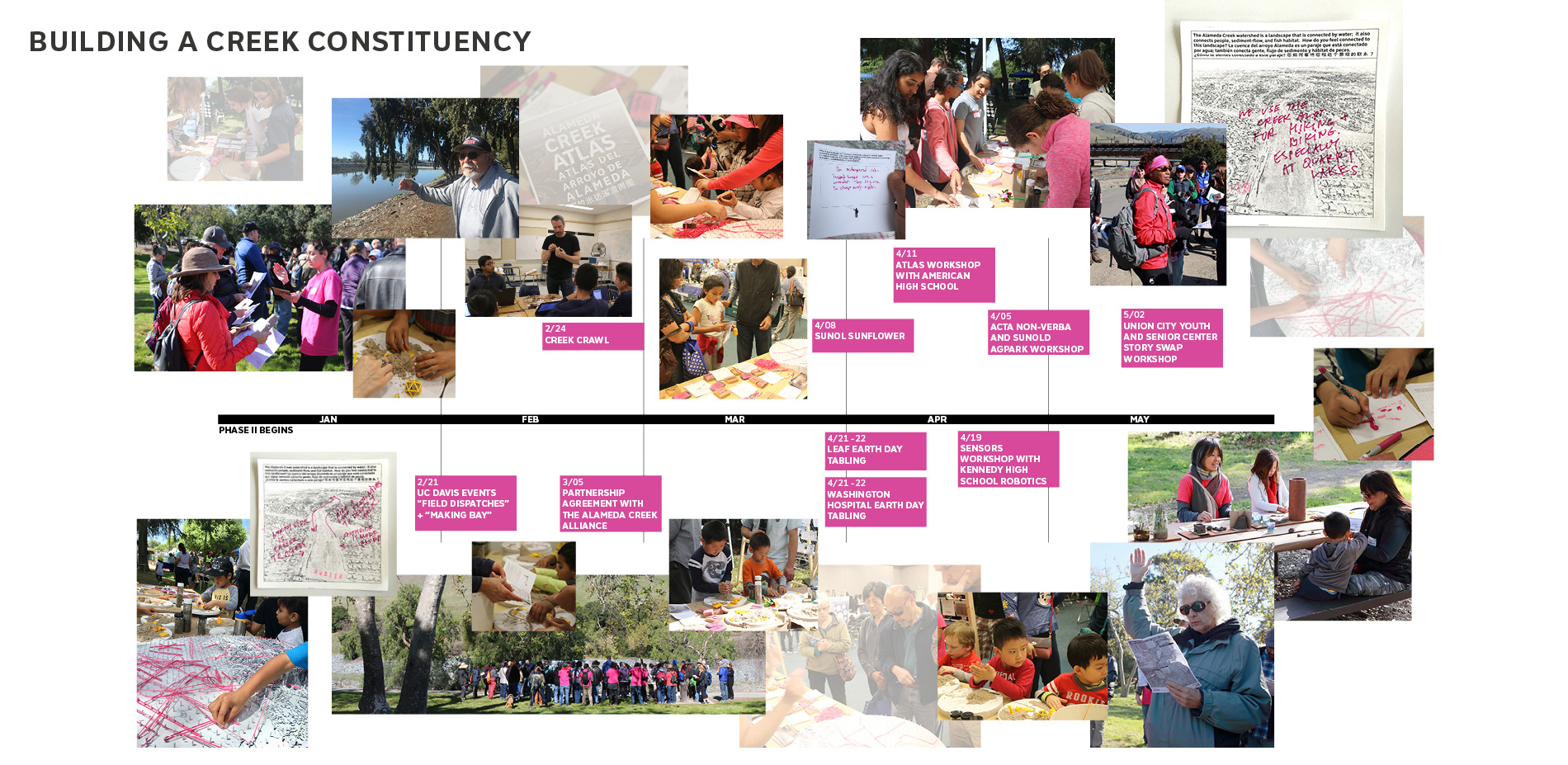
为了挽回阿拉米达溪作为景观资源的公共形象,项目团队在河岸地带举办了多次活动,试图了解公众对河岸现状的认知、记忆以及使用意向,并通过图册将人们的叙述记录下来,以反映他们对阿拉米达溪不断变化的态度,为生态系统的未来发展提出建议,同时让学生、年轻人和居民们参与到这一动态的环境当中。阿拉米达溪徒步项目还邀请了100多位社区居民和利益相关者前往防洪渠道进行参观,亲自体验他们久未触及到的河流景观。项目团队旨在通过这一系列努力在阿拉米达溪沿岸建立认同度更高的社区,使人们树立与河岸的资源发展相关的意识和积极性。
阿拉米达溪公共沉积物计划响应了“用设计构建适应力”(Resilient by Design)倡议,旨在提高人们对湾区海平面上升的意识并提出应对该问题的可行性解决方案。项目的设计阶段于2018年完成,并在NOAA/NFWF沿岸修复基金会的资助下以“卵石沙丘”作为首个试点工程,整体建造持续至2019年。
阿拉米达溪公共沉积物计划是一个测试性的项目。用于该项目的技术与合作关系可以作为整个湾区发展的行动先例。未来十年,共沉淀计划提出的工作方法和理念必将广泛地应用到其他支流沿岸,尤其是那些能够将大量沉积物带入河湾的支流、有大量沉积物积存在上游区域的支流,以及拥有巨大潮汐潜力并需要潮汐湾地垫层来支撑河口的支流。为了维持湾区的沉积物输入与支流输入量、海平面上升率以及恢复潮汐湾地和保护沿海环境之间的平衡,制定适应性的区域沉积物管理策略志在必行。阿拉米达溪公共沉积物计划体现了我们在以气候变化为目的的规划范式的转变上所迈出的一小步。

▲该方案旨在重新设计阿拉米达溪以创建一个能够以可持续方式运输沉积物的功能性系统,从而适应海平面的上升、吸引居民的参与并为鱼类提供栖息地。The proposal aims to redesign Alameda Creek to create functional systems that sustainably transport sediment for sea level rise adaptation, engage people, and provide habitat for anadromous fish.
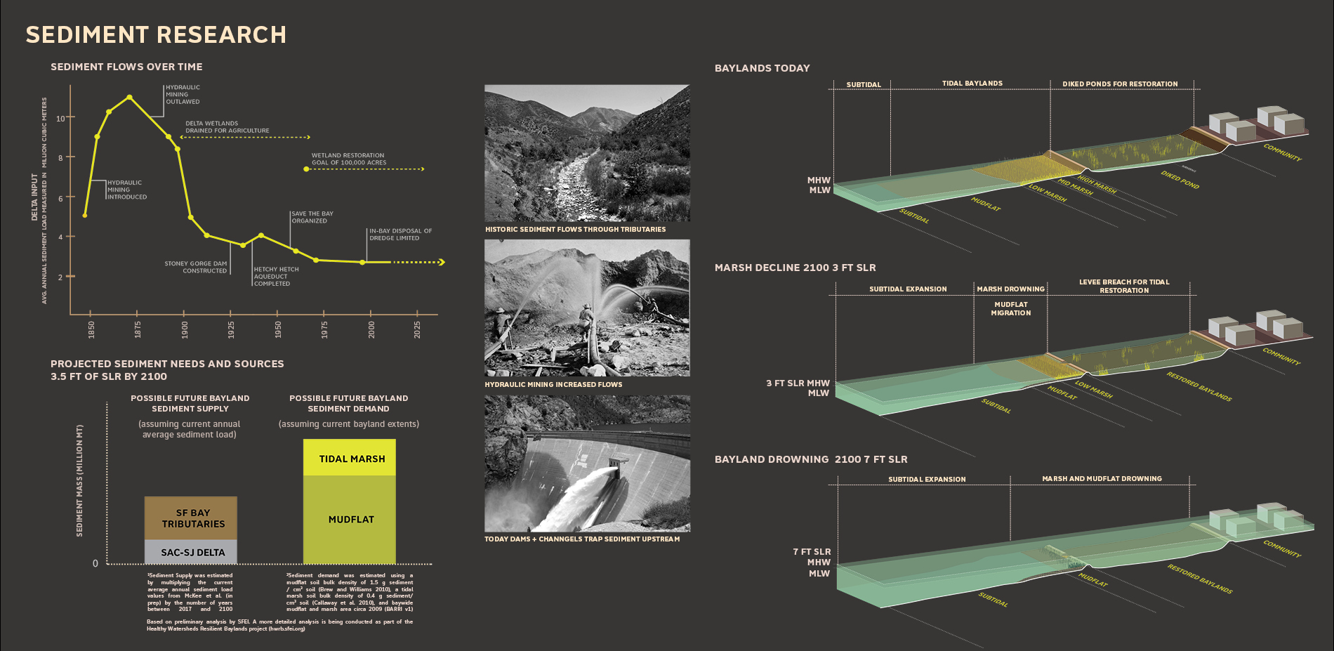
▲湾区转变的科学依据:该计划是基于对海平面上升和沉积物的供给不足导致的潮汐湿地生态系统沉陷和流失问题的科学性研究而开展。Translating Bay Area Science: The planning study built off scientific research in Bay Area on the subsidence and loss of the Bay’s tidal wetland ecosystems due to sea level rise and low sediment supply.
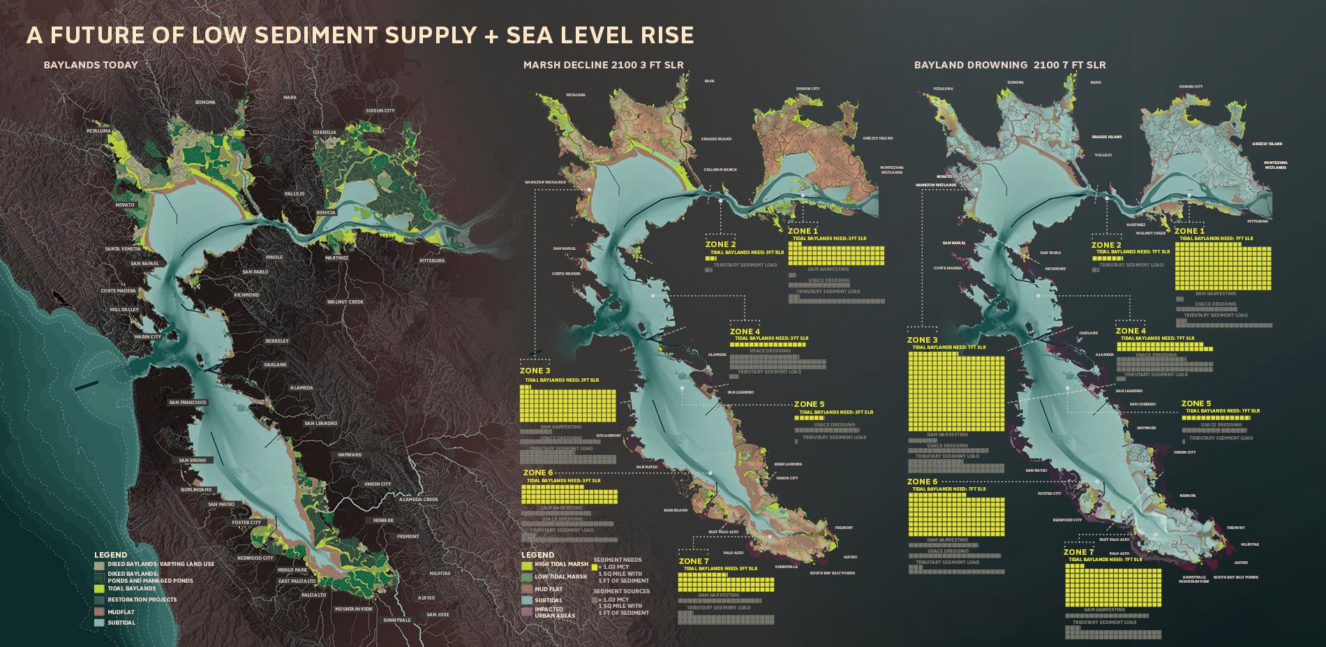
▲湾区陆地将如何改变?规划团队研究了湾区陆地随时间发生的潜在生态变化,并对研究内容进行了可视化,这也是对如此大规模的水土损失的首次可视化。其关注的重点在于区域范围内沉积物的供给和复原能力。How Will the Baylands Change? The planning team visualized ongoing scientific research on potential bayland ecological changes over time. This was the first time this scale of loss was visualized, focusing the regional conversation around sediment supply and resilience.

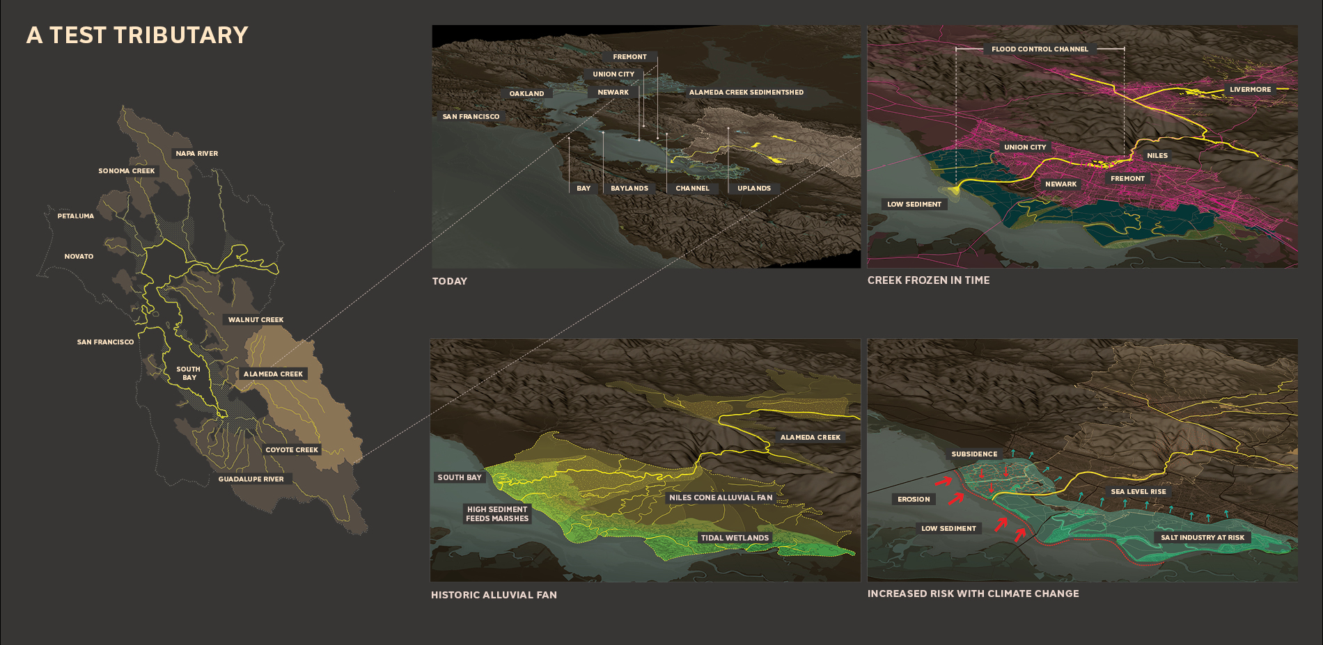
▲作为测试案例的支流:阿拉米达溪曾经是一道蜿蜒的水体,将富含沉积物的河水带往广阔的河漫滩。在1900年代中期多次发生洪灾后,河流实施了渠道化工程用以防洪。如今的沿河环境变得脆弱且不可持续。A Test Tributary: Alameda Creek was once a meandering waterbody that spread sediment-rich floodwater across a broad floodplain. After repeat flooding in the mid-1900s, the creek was channelized for flood protection. Today’s conditions are unsustainable and vulnerable.
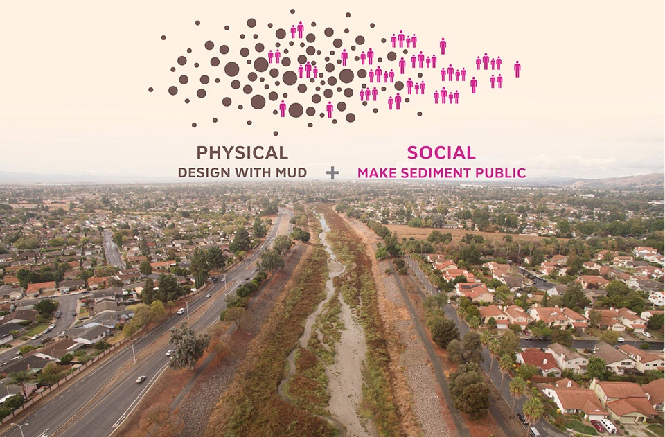
▲公共沉积计划概念:该项目旨在利用泥土进行设计,使沉积物成为阿拉米达沿岸公共生活的一部分。选择阿拉米达溪的原因是它是为湾区提供滋养物的当地最大支流。Public Sediment Concept: The project aims to design with mud and make sediment part of the public conversation in the Alameda Creek watershed. Alameda Creek was chosen as it is the largest local tributary that feeds the Bay.

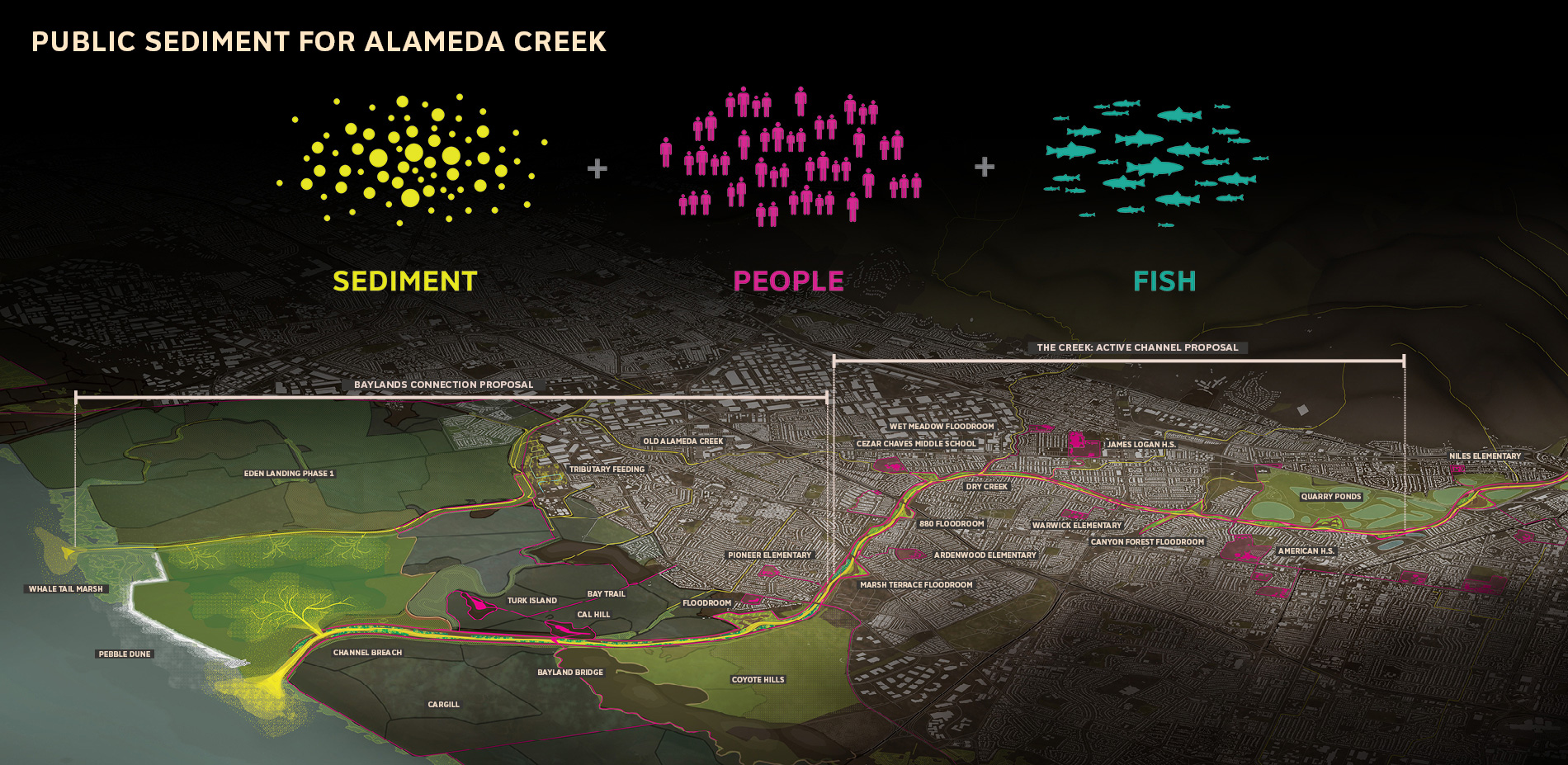
▲沉积物、人类、鱼类:该方案解决了菲蒙市、联合市以及纽瓦克市的脆弱沿海地带的沉积物短缺问题。规划的重点是河流与海湾两个方面。Sediment, People, Fish: The proposal addresses the challenge of sediment scarcity along the vulnerable urban edges of Fremont, Union City, and Newark. The plan focuses on two reaches of the waterbody: the Creek and the Bay.

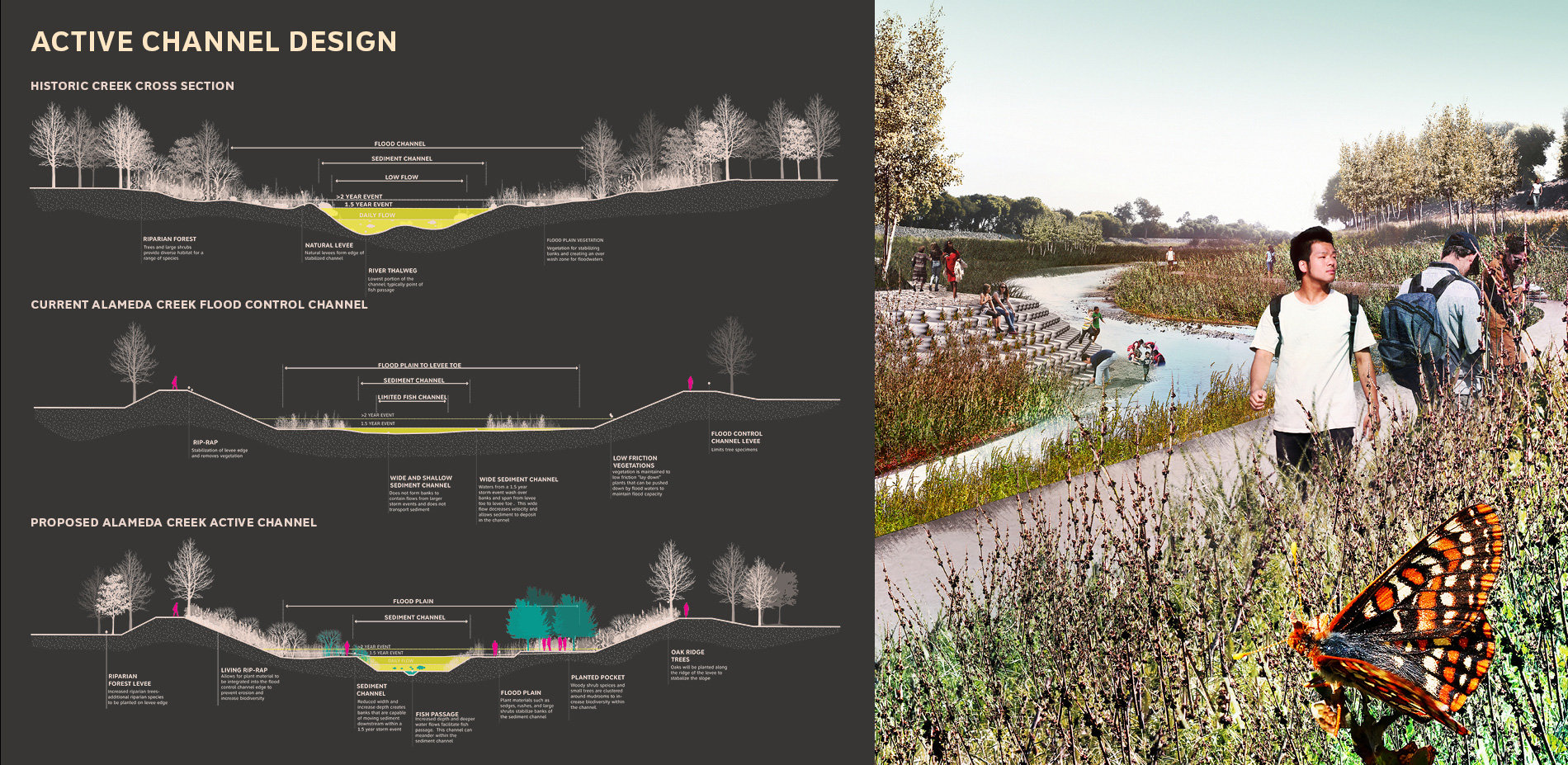
▲活跃的水道设计:美国陆军部队在1970年代对阿拉米达溪实施了渠道化工程,重塑并疏通了水道的底部,并通过引入稳定的植被来增加汛期沉积物的输入量,同时改善生态和防洪能力。Channel Design: The Creek was channelized in the 1970s by the US Army Corps. The design re-sculpts the channel bottom and introduces stabilizing vegetation to enhance sediment transport during seasonal floods and improve ecological and flood control function.
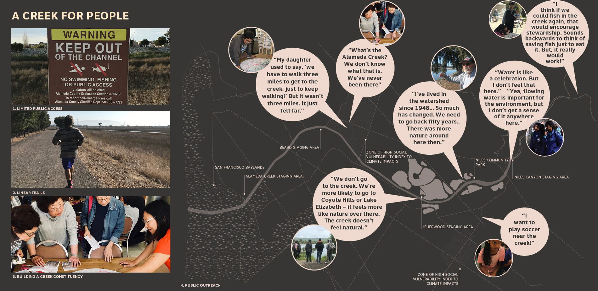
▲属于公众的河流:为了提高河流的资源价值并获得来自周边社区的参与和认可,项目团队在河岸地带举办了多次活动,并通过Creek Atlas记录了公众对河岸现状的认知、记忆以及使用意向。A Creek for People: A larger creek constituency is needed to value the creek as a resource. The team held events in the watershed and built a Creek Atlas to understand how people want to use the channel.
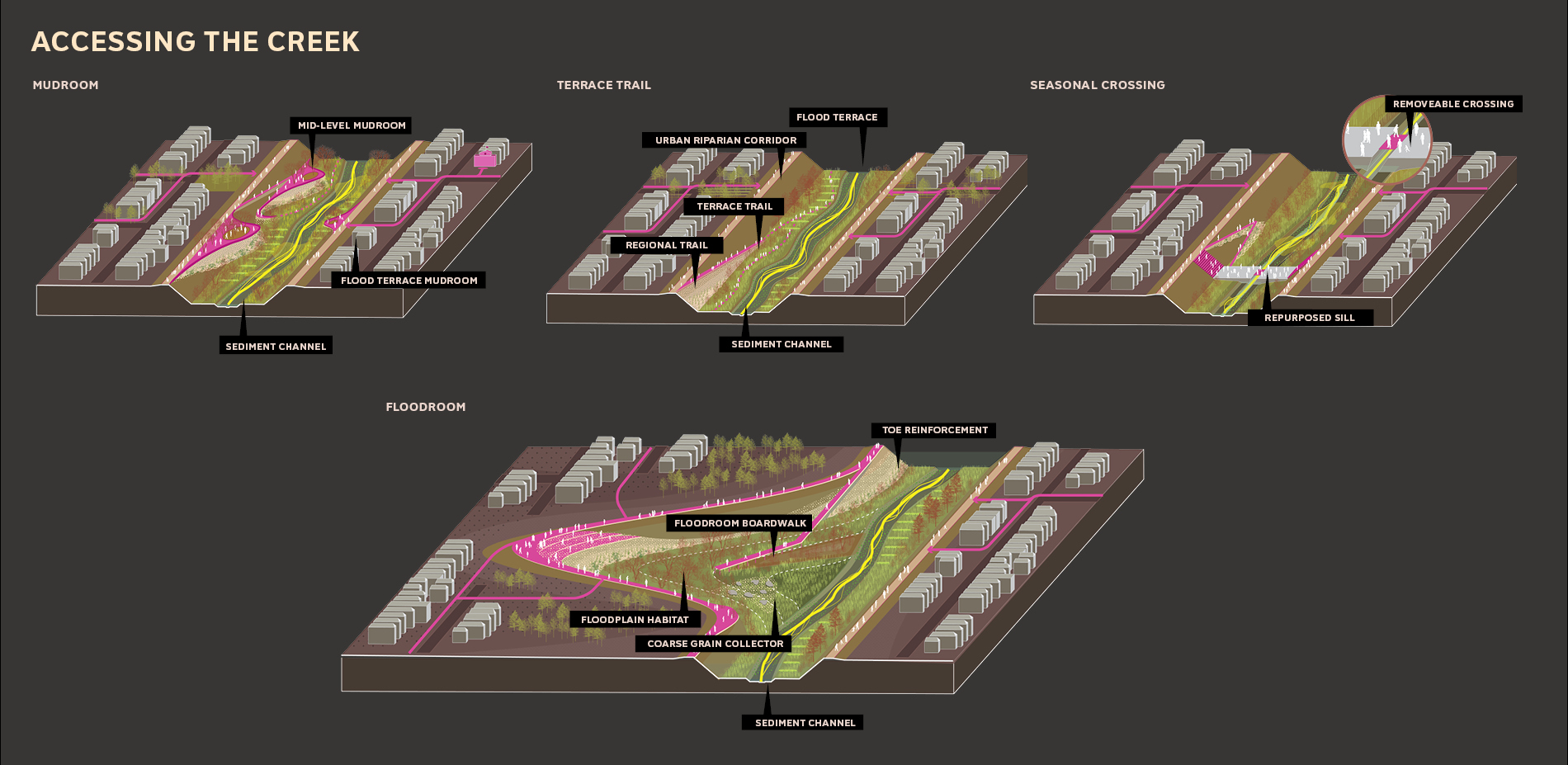
▲进入河流:本次计划提出建设四种类型的公共通道,包括泥沙室、蓄洪室、平台步道以及四季桥梁,每个通道都能够促进社区之间的联系和互动,并保证河流使用的安全性。Accessing the Creek: The project proposes four types of public access in the newly formed creek: Mudrooms, Floodrooms, Terrace Trails, and Seasonal Bridges. Each of these enables connectivity and exchange between neighborhoods and safe use of the creek itself.

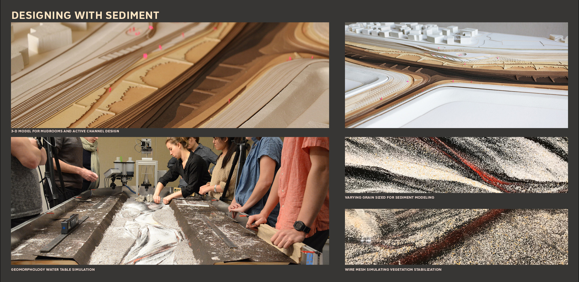
▲利用沉积物进行设计:项目团队借助动态模型和水文-地貌数据表格来研究对防洪渠内部植被和整治结构的策略性应用。研究的结果被转化为阐释性的物理模型。Designing with Sediment: The team used dynamic modeling and a hydro-geomorphology table to study strategic use of vegetation and creek training structures within fluvial portions of the flood control channel. These results were translated into an interpretive physical model.
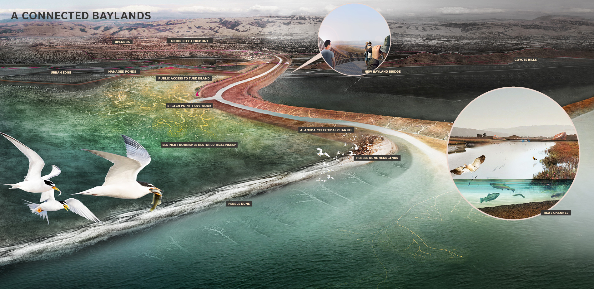
▲导流:对于湾区陆地的长期发展而言,水流的引导起着至关重要的作用。本次计划方案旨在通过连接河流和湾区陆地来协调湾区边缘的人、沉积物以及鱼类的生存环境。Breaching the Creek: Connecting the creek to the baylands is critical for long term tidal bayland survival. The proposal will breach the creek while balancing the needs of people, sediment, and fish at the Bay’s edge.

▲湾区陆地的连接:阿拉米达溪公共沉积物计划代表了以应对气候变化为目的的规划范式的转变 – 比起加固湾区边缘,更重要的是投入精力去维护随时间不断壮大的生物系统以适应海平面的上升。Baylands Connection: Public Sediment for Alameda Creek represents a paradigm shift in climate change planning – rather than hardening the edge, we must invest today in living systems that will grow over time to adapt to sea level rise.
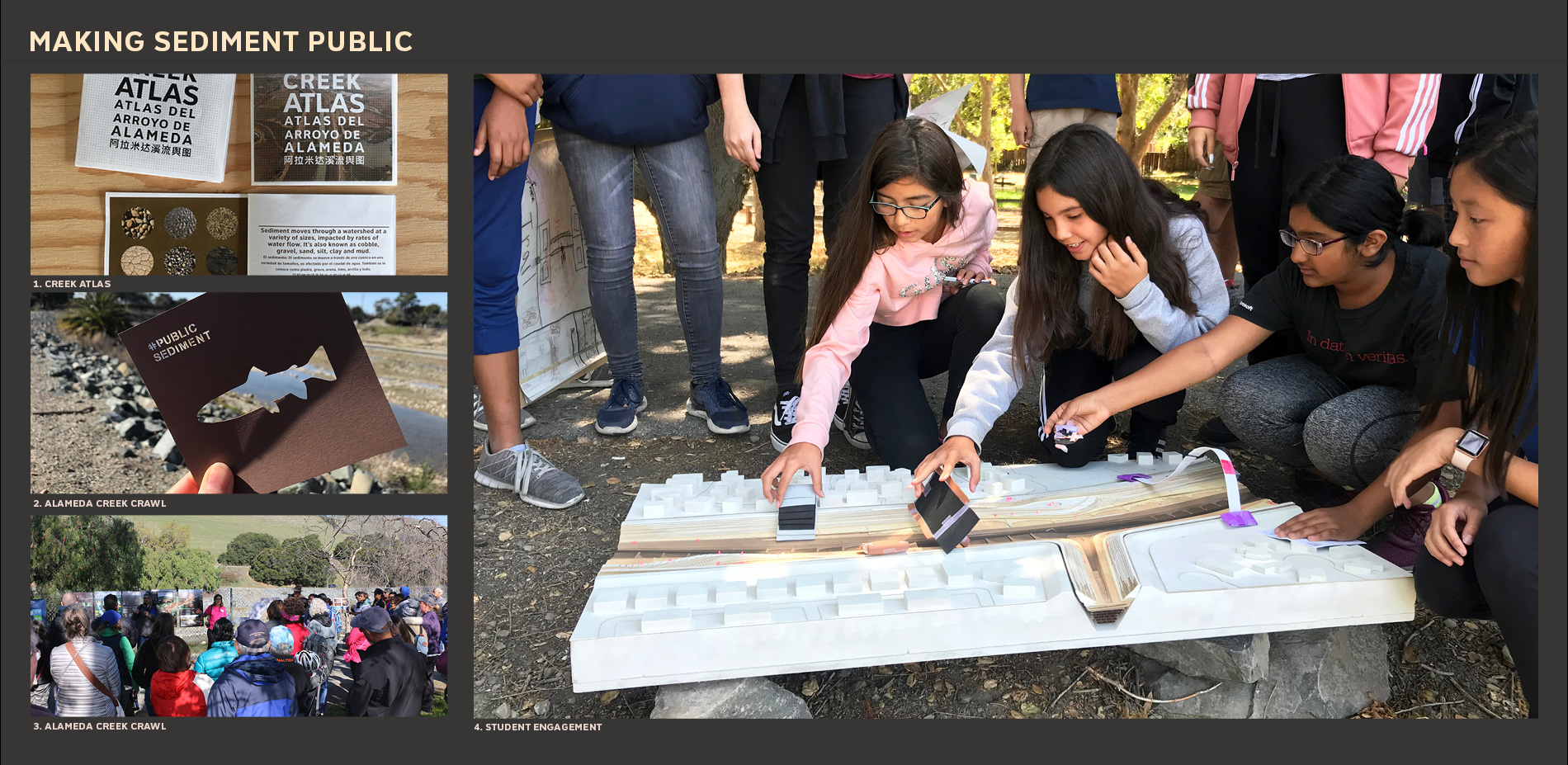
▲让沉积计划走向公众:规划的实施有赖于与社区的合作,将沉积物作为与水和空气相同的公共资源进行集体化管理。参与工具的使用将有助于连接居民与土地的历史。 Making Sediment Public: To enable this shift, we must work with communities to reveal sediment as a public resource, to be collectively managed like water and air. Engagement tools were used to connect people with the story of mud.
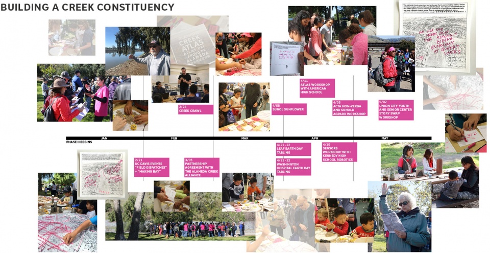
▲强化沿岸社区:项目团队在河岸地带举办徒步、演讲和工作坊等一系列活动,试图围绕公共沉积物资源来构建具有更高认同度的沿岸社区。Building a Creek Constituency: Through public events in the watershed, including walking tours, presentations, and workshops, the proposal advocates for building a stronger creek constituency organized around public sediment resources.
▲区域性的变化:该区域存在着无形的风险,并会随着时间的推移急剧加重 – 阿拉米达溪公共沉积物计划是在区域重建支流的引领性的范例,这些支流将为未来的几代人构建功能性的生态系统以维护受潮汐影响的湾区陆地。Regional Change: The region’s risks are invisible, yet they increase dramatically over time – Public Sediment for Alameda Creek is the beginning of a regional effort to reinvest in tributaries as functional ecosystems that sustain tidal baylands for future generations.
Tidal ecosystems are protective infrastructure that cushion the urban edges of the San Francisco Bay. These systems require sediment to grow vertically in response to sea level rise–without sediment, our baylands will drown. Low sediment supply due to upstream dams and channelization represents a slow but devastating scale of loss that threatens ecosystems, recreational landscapes, and places hundreds of thousands of residents and the region’s critical drinking water, energy, and transportation systems at risk.
Public Sediment for Alameda Creek is a proposal that addresses the challenge of sediment scarcity along the vulnerable urban edges of Fremont, Union City, and Newark. To bring sediment to the baylands and adapt to sea level rise, our team looks upstream to Alameda Creek, the largest local tributary that feeds the Bay. The proposal aims to redesign this waterbody to create functional systems that sustainably transport sediment for sea level rise adaptation, engage people, and provide habitat for anadromous fish.
Alameda Creek was channelized to protect the neighborhoods of Fremont, Union City, and Newark from extreme floods. Historically, the creek fed the tidal baylands directly with sediment, nourishing this living infrastructure over time. But now, the channel has sterilized a living system. While the system can never return to its past state, Public Sediment for Alameda Creek proposes to reintroduce sustainable sediment flows, ecological connectivity, and public access back to the creek to address the climate change threats of the future. The project builds on work developed by the Alameda County Flood Control District (low-flow channel), and collaborations between many partners in the watershed around enhanced fish passage including the Alameda Creek Alliance, Alameda County Water District, the Fisheries Restoration Work Group and many others.
The channel was not designed to move sediment. Today, coarse grain sediment builds up in the channel, reducing flood storage capacity and creating a continual need for dredging. The project proposes to redesign the channel for increased sediment flows, excavating a bankfull sediment channel that moves sediment downstream during annual floods, stabilizing it with vegetation. The new channel is projected to bring an additional 5,000 cubic yards of sediment to the bay annually, creating habitat and introducing moments of public access in and across the creek.
Many species depend on a connected creek for survival. Historically, Alameda Creek hosted some of the largest runs of steelhead trout in the region. Today’s these runs are all but lost due to channelization and barriers to passage. Plans are underway to add fish ladders to major infrastructure crossing, but even with these improvements, the wide and shallow cross section of Alameda Creek inhibits the successful migration of steelhead. The project proposes to construct a deeper fish channel that creates deeper flows for fish passage and introduces more diverse vegetation in the channel. Floodrooms expand critical foraging and refuge areas, for steelhead and a wide variety of floodplain-dependent species.
The channel and its levee infrastructure also impact local communities, separating wealthy, middle income, and disadvantaged communities in the large and diverse suburbs of Fremont, Union City, and Newark. While the levee trails are popular, people are isolated to the upper edge, not able to access the water, cross the creek, or participate in the changing system of the creek. We propose four types of public access: Mudrooms, Floodrooms, Terrace Trails, and Seasonal Bridges. Each can respond to flooding events, with managed access during the winter season.
Public Sediment for Alameda Creek proposes to directly connect the sediment flows of the fluvial creek system with the future tidal baylands at Eden Landing. Breaching the creek is critical for long term tidal bayland survival: even in its compromised state, the Alameda Creek watershed moves enough sediment to nourish the restored tidal marshes with moderate rates of sea level rise. Although breaching appears simple, in practice it is a complex choreography of physical and regulatory conditions that balance flood risks, liability, habitat tradeoffs, and public access requirements. The proposal connects the creek to the baylands to balance the needs of people, sediment, and fish at the Bay’s edge. The bayland portion of the project builds on work developed by the South Bay Salt Pond Restoration Project at Eden Landing, California Fish and Wildlife, the Alameda County Flood Control District, East Bay Regional Parks, the Bay Trail, and others.
Public Sediment for Alameda Creek proposes a multi-part strategy to connect sediment with the baylands and address short and long-term flood risks. The series of flood risk reduction actions includes the construction of a mid-complex levee to separate managed ponds from tidal ponds, and the construction of a perimeter “Pebble Dune” that mimics a barrier island, reducing tidal forces and protecting the baylands from wave action and erosion. With these interventions in place the creek can be breached, sediment can enter the baylands, and a new wetland cushion can be nourished over time.
The channelization of the creek has severely limited an estuarine mixing zone, transforming what was historically a wide marsh plain of shallow meandering sloughs into a single linear channel. The breach reintroduces this mixing zone, creating space for a range of species like juvenile steelhead, which require this transitional space to adapt to a salt water environment.
The proposal also includes a series of new destinations in the baylands, including an extension of the bay trail and a Breach Bridge that jumps the channel and moves with the tides, linking the greater path network of Eden Landing and providing a clear overlook to the newly forming delta.
The transformation of Alameda Creek from creek to flood control channel has erased its public identity as a landscape resource. The project team has been holding events in and around the Creek to understand how people perceive this space today, how they remember it, and how they want to use it. The Creek Atlas synthesizes these narratives and reflects on changing attitudes towards Alameda Creek, suggesting new futures for the ecosystem while engaging students, youth, and residents in this dynamic environment. The Alameda Creek Crawl invited over 100 residents and community stakeholders to look past the flood control channel and experience the living creek hidden in their backyards. With these efforts, the team aims to build a stronger constituency for the creek and develop awareness and activism around resources for the future.
Public Sediment for Alameda Creek was developed for the Resilient by Design Initiative, an effort to raise awareness and develop implementable solutions for sea level rise adaptation in the Bay Area. After the completion of the design phase of this project in 2018, the project is funded for pilot design of the Pebble Dune system by the NOAA/NFWF Coastal Adaptation Grants and continues into 2019 as an active initiative.
Public Sediment for Alameda Creek is just a test. Looking beyond the single tributary, the techniques and partnerships piloted in Alameda creek can serve as precedent for bay-wide action. Over the next decade, the Public Sediment methodology and ethos must be applied to other tributaries, particularly tributaries that contribute large volumes of sediment to the bay today, tributaries with large volumes of sediment trapped upstream, or tributaries with the most potential or need for tidal baylands cushions at their mouth. An adaptive sediment management strategy must be developed for the region that balances the sediment inputs to the bay with local tributary inputs, sea level rise rates, and tidal bayland restoration and coastal protection goals. Public Sediment for Alameda Creek represents a small step towards a paradigm shift in how we plan for climate change.